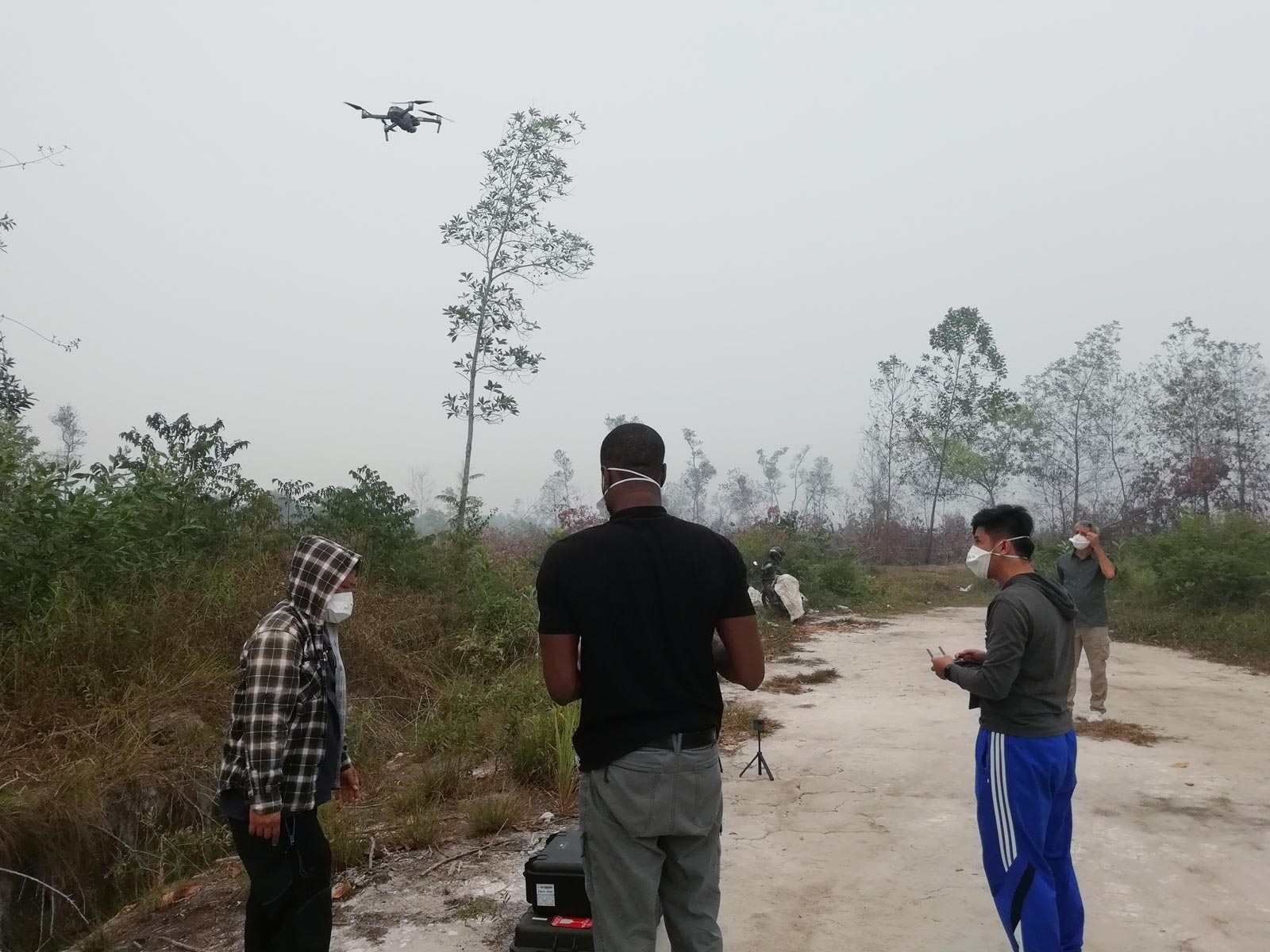
In a remote area of the Indonesian portion of Borneo, a technician calmly fiddles with a remote control. A mask shields the bottom half of his face from thick wafts of smoke as a drone buzzes away above, scouring large swathes of blazing forest with a thermal infrared detector mounted on its underside.
The information the drone gets is sent back to a server kilometres away, providing a team of local firefighters with valuable context as they prepare to put their lives on the line battling the blazes.
An example of the increasingly important role technology is playing in wildlife and forest conservation, this small-scale experiment that started in 2018 is the offspring of a collaboration between Liverpool John Moores University in the UK, the Borneo Nature Foundation and the University of Palangka Raya in Indonesia.
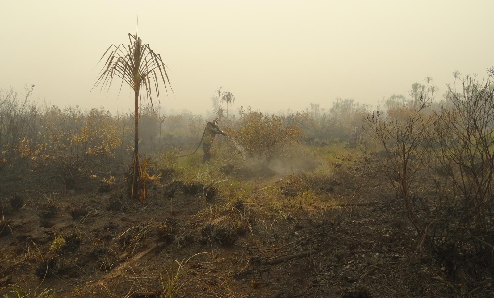
The project is working to address a challenge relatively unique to these fires in Indonesia and those attempting to stamp them out – a large proportion of them are burning underground.
Because much of the Borneo is covered in peat – an accumulation of decaying vegetation or other organic matter common to wetter areas – wildfires can travel underneath this top layer and spread without the knowledge of firefighters or locals.
“Some of [the indicators for fire] are obvious: there will be some flames coming up above the surface,” explained Mark Harrison, the director of the Borneo Nature Foundation.
“But some of the fires will be burning beneath the surface, and may not have flames above the surface. So they’re still burning, and given time, they will come up, but you can’t necessarily see where those are just from standing on the surface,” he added, saying that thick haze and smoke exacerbate the problem further.
The goal of it really is to make the firefighters’ jobs easier by planning their firefighting strategy, and then also to make it safer for them as well
Mark Harrison, Borneo Nature Foundation director
These factors mean the danger of battling peat fires increases exponentially as firefighters have to venture out into potentially compromised territory to access the blaze and make headway in fighting it. One wrong step could result in significant burns to legs and arms, or even death in worst case scenarios.
According to Harrison, dry peat also makes the fires harder to put out because as well as dousing flames on the surface, the peat must be saturated all the way down, requiring much more water than is needed for typical forest fires.
But following the introduction of drones mounted with thermal cameras, transmitting images to on-the-ground servers instantly, Indonesian firefighters can focus their limited resources wisely, knowing where to direct their energy while staying safer doing it.
“The goal of it really is to make the firefighters’ jobs easier by planning their firefighting strategy, and then also to make it safer for them as well,” said Harrison.
In recent months the wildfires sweeping Australia have captured the attention of people worldwide, making it difficult not to situate the Borneo team’s research within the context of other similarly intense weather events globally.
Slowly escalating in severity and frequency for decades, Indonesia’s fires have also become an annual issue, with their huge land mass – this past year they easily surpassed the high-profile blazes in the Amazon rainforest – presenting a growing hazard to the health and livelihoods of communities living across the country.
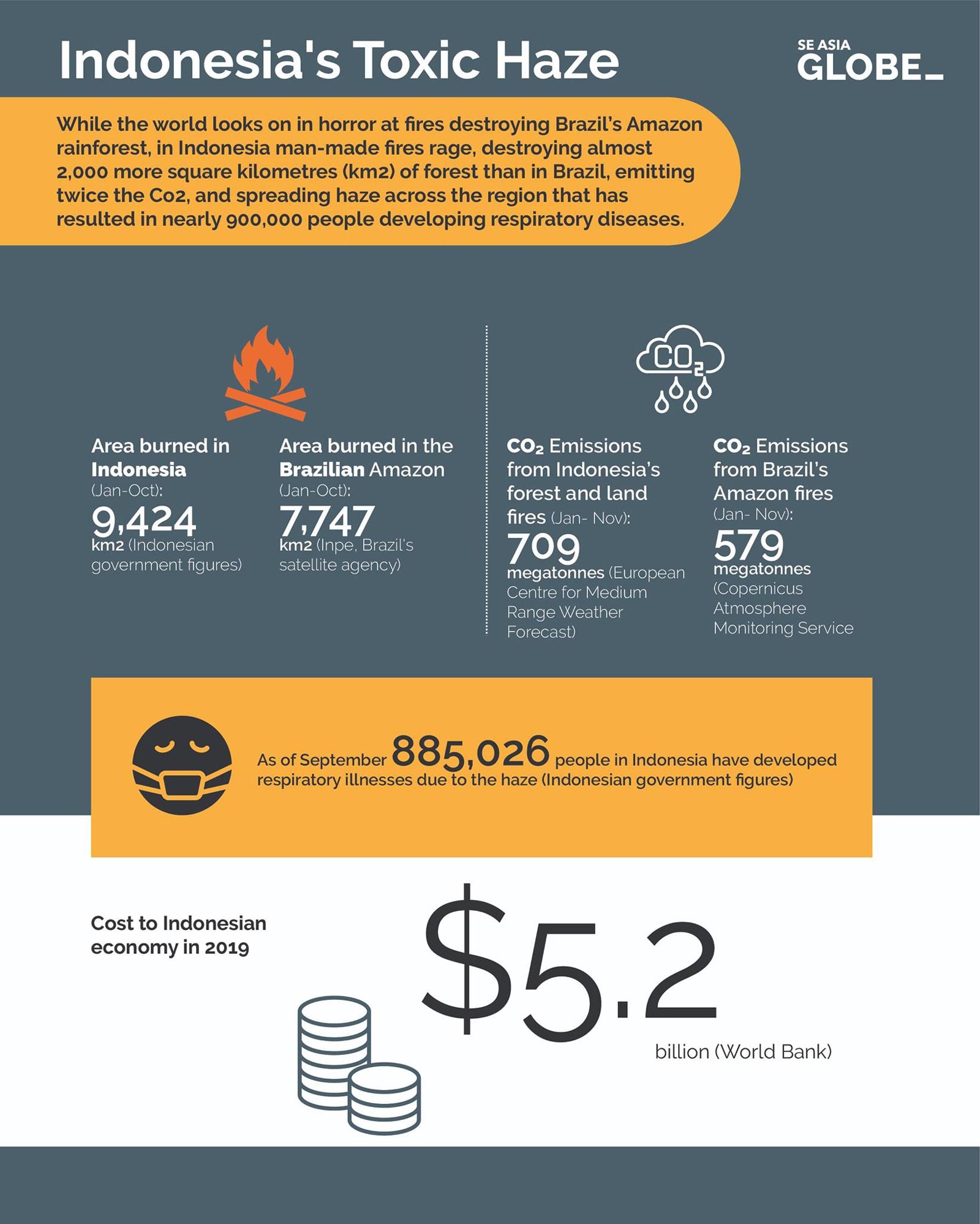
Since the world’s peat stores contain more carbon than the entirety of the world’s forests, Indonesia’s forest fires are also a significant contributor to global CO₂ emissions. In 2015, during the “super” El Niño heat phenomenon, Indonesia’s fires contributed just under a fifth of the total carbon emissions that year – more than the combined contributions of the global transport sector.
Petris Perkasa, a researcher from the Center for International Cooperation in Sustainable Management of Tropical Peatland (CIMTROP) at the University of Palangka Raya in Borneo’s Central Kalimantan province, calls the wildfires the region’s “annual disaster”.
“We have to race against time. If we waste the time, fires will become bigger and more widespread,” he said.
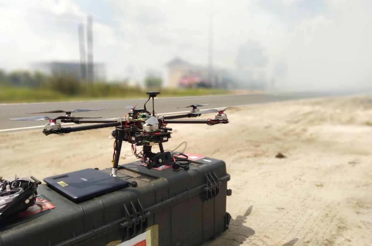
While drones and thermographic cameras are increasingly aiding in this fight, they are by no means new inventions. What’s changed is that they’ve become more efficient, commonplace and affordable, enabling organisations and researchers to experiment in using the technology to combat persistent ecological problems.
The technology, which allows large areas to be surveyed from above remarkably quickly and can detect the heat transferred to the surface above a fire, saves crucial moments in instances such as Indonesia’s peat fires, which can quickly and discretely engulf land.
Professor Serge Wich, one of the leads of the Borneo project and a pioneer in the field, is working on a variety of experiments using surveillance technology in conservation.
He started his career as a biologist in 1993 studying the eating behaviour of orangutans in Indonesia, but seeing land consistently lost to a variety of causes, he felt an urgent need to protect the area. Alongside colleagues, Wich started using a drone to observe more of what was going on, with things moving from there.
Today, one project has him working with a team to develop low-cost camera traps – tiny cameras set up across a given area with a motion-activated trigger system – to try and develop an early warning system for when elephants come close to human settlements. This allows action to be taken before the elephants damage crops or humans hurt the animals.
These projects all have one thing in common, explained Wich.
“It’s all to try to provide the people in the field with the data they need with very little effort from them,” he said. “Those are very busy situations when [people are in the field on a project], so it has to be as easy as it can be for them, and getting there is what many people are trying to work on.”
The potential of technology to aid in the fight against poaching and deforestation has become a hot topic in conservation circles. In December, the Zoological Society of London put on a conference – which Wich presented at alongside three other researchers – giving attendees a glimpse into potential applications.
“Machine learning is opening up new ways to tackle rule-breaking, using ranger reports, thermal and aerial imagery, and vessel positioning data,” the event page reads.
Fauna & Flora International (FFI), the world’s oldest international wildlife conservation organisation, has long used technology to their advantage as they work to address conservation problems.
Henry Duffy, a Marine Technical Specialist for FFI specialising in the Asia-Pacific region, points to the organisation’s spatial monitoring and reporting tool (SMART). It combines GPS technology with software for measuring, evaluating and improving the effectiveness of wildlife law enforcement patrols and site-based conservation activities.
In Cambodia, for example, they have worked in the communities around the Koh Rong archipelago for more than a decade, and use SMART to identify hotspots of illegal fishing activity.
“Illegal fishing is a really interesting area, because it’s so hard to detect within the waters of quite a small country like Cambodia, let alone the international waters and the vast areas that involves,” said Duffy. “So I think technology has fascinating implications there, just to be able to see things that there aren’t the human resources to record.”
Enabling the growth of technology in the field is its growing affordability, and with much of their work centring around low-income countries, the Borneo team’s research is also concerned with the accessibility of the equipment they use.
“That’s one of the reasons why for this particular project we’re using off the shelf drones from DJI, [the market leader in easy-to-fly drones and aerial photography systems] we want to scale these things up. And so if we use off-the-shelf systems that are relatively affordable and provide the workflow with that, then it becomes much easier to scale this up,” said Wich.
Whilst we definitely try and use technology where possible to be more efficient, we definitely recognise the limitations
Henry Duffy, a Marine Technical Specialist for Fauna & Flora International
“Then we can just buy a large number of these drones, they’re easy to fly, and then hopefully, the usage of this technology will spread to other regions.”
Wich also co-founded ConservationDrones.org, an initiative that seeks to share knowledge of building and using low-cost unmanned aerial vehicles for conservation-related applications with conservation workers and researchers worldwide, especially those in developing countries.
The initiative is focused on not only raising public awareness of the conservation challenges in the world’s more remote regions, but also on inspiring others to adapt emerging technologies for their own conservation efforts.
ConservationDrones.org even has a tab labelled “HOW TO BUILD A DRONE”, which offers information on everything from what equipment to buy, to how to set up a live transmission of flight data to a ground control station.
Wich acknowledges the obvious privacy concerns presented by the proliferation of advanced surveillance technology. Humans aren’t so different from orangutans after all, and – in light of how much data is collected from every smartphone – it’s not difficult to imagine this same technology applied to tracking people.
“The issue is, how do you potentially deal with the sort of ‘Big Brother’ idea, that technology is monitoring people everywhere?” he asks.
But at least personally, Wich is committed to working within national regulations and adhering to his own personal code of conduct to determine when this technology is necessary, and how to protect animals and the environment without infringing upon the rights of people.
Duffy, similarly, also underscored the need to be sensitive to local needs and perceptions when introducing technology into conservation efforts.
“Whilst we definitely try and use technology where possible to be more efficient, we definitely recognise the limitations and when it comes to building that community connection … how to be aware of how technology might be perceived by those at the site,” said Duffy.
According to Eddie Lefter, the head of Wildlife Alliance’s Southern Cardamom Forest Protection Program, technological innovations are not a one-stop answer to all conservation problems. He was blunt in an interview with Southeast Asia Globe, saying technology is not useful when used in certain situations and terrains.
“It’s not compatible with us, with our environment,” said Lefter, who also works closely with the Alliance’s Wildlife Rescue Team, the only law enforcement in the region dedicated to cracking down on wildlife trafficking and illegal poaching full-time.
He described the wet, humid depths of Cambodia’s Cardamom Forest – which causes any cameras to fog up immediately. And while surveillance drones are sometimes able to get past the dense canopy of trees and capture poachers engaging in illegal activity, the team may only get to the area 20 minutes later and find they have left.
Instead, he sees a boots-on-the-ground approach as the only viable way to tackle moving targets like illegal poachers.
“Here, many people don’t like that, especially donors … but it’s boots on the ground, only, nothing else, that can stop and fight.”
The Wildlife Alliance team alluded to the development of strategies to combat wildlife crime taking place on social media platforms, but declined to say anything further on the topic.
Others, however, see more promise in overcoming these technological limitations.
This past September, the Borneo research team went back to the region and practiced using the drones in the haze to detect hotter thermal areas where fires were located – and it worked. They left the drones with the Borneo Nature Foundation, who helped local firefighters use them for the rest of the dry season, which runs from April to October in Indonesia.
Wich acknowledges that the project hasn’t developed to a point where the detection of fires by drones is entirely automated and instantly transmitted to firefighters, but they hope to get there in the coming years.
CIMTROP researcher Perkasa similarly hopes that eventually they will be able to develop a full-fledged information centre that connects drones, satellite hotspots and firefighting teams in real time, so that any fires can be addressed as quickly and safely as possible.
But while these technological innovations being used in conservation remain a long way off from being universally applicable, the Borneo team remains cautiously optimistic about the future.
“Yes, definitely,” Wich said when asked if he can see the Borneo project’s methods being adapted for problems in different regions around the world. “We’ve already had interest from other regions in Indonesia for this.”